
A marine GPS helps you navigate safely by using waypoints, which mark key locations like hazards or landmarks, and tracks that record your route for future reference or backtracking. You can set and manage these features to stay on course, analyze past paths, or create safe return routes. Modern GPS also offers alerts if you drift off course, making your voyage safer and more efficient. Continue exploring to discover how these tools can enhance your navigation skills.
Key Takeaways
- Waypoints mark key locations to navigate accurately and avoid hazards during maritime routes.
- Tracks record and display the path traveled, aiding in route analysis and backtracking.
- Setting and managing waypoints helps create safe, reliable return routes for complex or challenging passages.
- Analyzing track data optimizes future navigation, ensuring efficiency and safety.
- GPS safety features, like deviation alerts, enhance confidence and prevent navigation errors at sea.
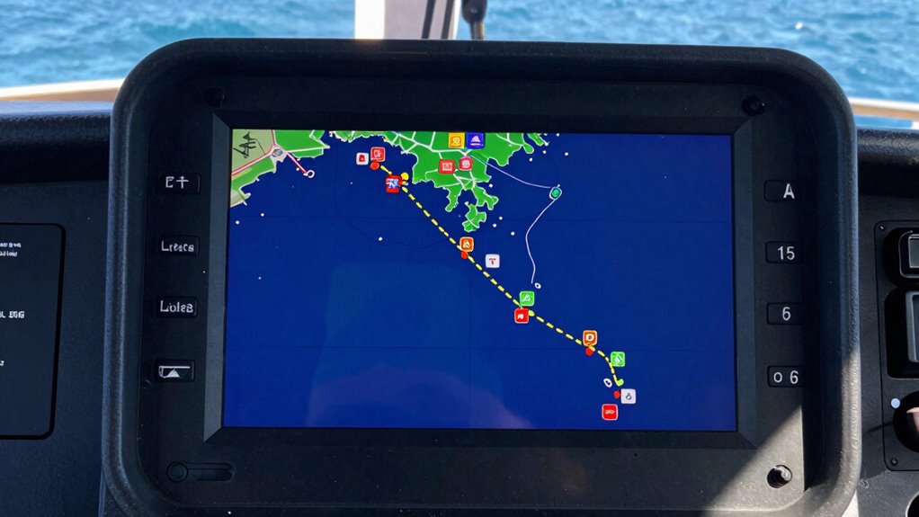
Marine GPS is an essential tool for navigation at sea, providing real-time positioning that helps you stay on course and avoid hazards. With advancements in GPS technology, you can now rely on highly accurate data to guide your vessel through complex maritime navigation. Knowing how to use waypoints, tracks, and safe return routes is *crucial* for a smooth, safe voyage, especially in unfamiliar waters. GPS technology allows you to set specific points along your route, making it easier to navigate through challenging conditions or restricted channels. Accurate maritime navigation is vital for ensuring safety and efficiency during your voyage. Waypoints are specific locations you designate as markers on your route. You can set these points manually or let your GPS device automatically mark significant locations such as buoys, landmarks, or hazards. Once established, waypoints act as navigational anchors, helping you plot a precise course and ensuring you don’t drift off track. They’re especially useful when retracing your route or avoiding obstacles, as you can program your GPS to alert you when you deviate from your intended path. This proactive approach enhances safety, giving you confidence in your maritime navigation. Tracks are a series of connected waypoints that form a path you’ve traveled or plan to follow. When you’re heading into unknown waters, recording your track allows you to recreate your route later or return along the same path. Many GPS systems automatically log your track as you move, providing a visual trail you can review on the screen. This feature proves *indispensable* if you need to backtrack or navigate through complicated areas where landmarks aren’t visible. By analyzing your track data, you can identify safe passages, avoid previously encountered hazards, and optimize future routes. Understanding how to utilize waypoints, tracks, and safe return routes with GPS technology enhances your maritime navigation skills. It provides a structured, reliable way to plan, execute, and adjust your voyage, ensuring safety and efficiency at sea. Additionally, familiarizing yourself with GPS safety features can further improve your navigation confidence and safety.

Garmin GPSMAP 79sc, Marine GPS Handheld Preloaded with BlueChart g3 Coastal Charts, Rugged Design and Floats in Water
- Durable, Floating Design: Water-resistant and floats in water
- High-Resolution Display: Clear, scratch-resistant, fogproof glass
- Enhanced Memory Capacity: Stores 10,000 waypoints, 250 routes, 300 activities
As an affiliate, we earn on qualifying purchases.
As an affiliate, we earn on qualifying purchases.
Frequently Asked Questions
How Do I Update My Marine GPS Software Safely?
To update your marine GPS software safely, first check for official updates from the manufacturer’s website or your device’s app store. Download the latest software using a secure internet connection, preferably on a computer, then transfer it to your GPS device via a USB or SD card. Follow the manufacturer’s instructions carefully, and make sure your device has a full battery or is plugged in. Safety precautions prevent data loss and device malfunction during updates.
What Should I Do if My GPS Loses Signal?
When your GPS loses signal, think of it as losing your lighthouse in fog. You should activate signal boosting techniques like adjusting the antenna or moving to an open area to reconnect. Be aware of satellite interference, which can block signals. Keep a backup navigation method, like paper charts or a handheld GPS, ready. This way, you maintain safe navigation even when technology lets you down temporarily.
Can I Use Marine GPS Offline Without Satellite Connection?
Yes, you can use marine GPS offline without a satellite connection by relying on offline navigation features. Many modern GPS devices store maps and waypoints locally, giving you signal independence when you’re out of satellite range. Make sure you’ve preloaded all necessary maps and routes before your trip. This way, you can confidently navigate even if your satellite signal drops, maintaining safety and route awareness throughout your journey.
How Accurate Are Marine GPS Position Readings?
Marine GPS position readings are generally accurate within 3 to 10 meters, thanks to satellite signals. Did you know that modern systems often achieve a 95% confidence level in positional accuracy? When you rely on a satellite signal, your GPS device processes multiple signals simultaneously, ensuring you get precise location data. This high accuracy helps you navigate safely, especially in challenging conditions or unfamiliar waters.
What Are the Common Causes of GPS Jamming at Sea?
GPS jamming at sea often results from electronic interference or signal blockage. Electronic interference from nearby electronic devices or intentional jamming devices can disrupt signals, making your GPS unreliable. Signal blockage occurs when large structures, dense weather conditions, or even underwater obstacles interfere with satellite signals. Staying aware of potential sources of interference and avoiding areas with known signal obstructions can help maintain your GPS accuracy and safety while steering.
Garmin GPSMAP 79sc, Marine GPS Handheld Preloaded with BlueChart g3 Coastal Charts, Rugged Design and Floats in Water
- Durable, Floating Design: Water-resistant and floats in water
- High-Resolution Display: Clear, scratch-resistant, fogproof glass
- Enhanced Memory Capacity: Stores 10,000 waypoints, 250 routes, 300 activities
As an affiliate, we earn on qualifying purchases.
As an affiliate, we earn on qualifying purchases.
Conclusion
Think of your marine GPS as your trusty compass on a vast ocean. By understanding waypoints, tracks, and safe routes, you’re steering confidently through unfamiliar waters. With this knowledge, you’ll navigate like a seasoned sailor, avoiding storms and dead ends. Just as a lighthouse guides ships home, your GPS keeps you on course, ensuring a safe and smooth voyage. Embrace these basics, and your adventures will always find their way back to harbor.
Garmin GPSMAP 79sc, Marine GPS Handheld Preloaded with BlueChart g3 Coastal Charts, Rugged Design and Floats in Water
- Durable, Floating Design: Water-resistant and floats in water
- High-Resolution Display: Clear, scratch-resistant, fogproof glass
- Enhanced Memory Capacity: Stores 10,000 waypoints, 250 routes, 300 activities
As an affiliate, we earn on qualifying purchases.
As an affiliate, we earn on qualifying purchases.

Garmin ECHOMAP UHD2 94sv with GT56 Transducer, 9" Touchscreen Chartplotter, Garmin Navionics+ U.S. Coastal (Renewed)
As an affiliate, we earn on qualifying purchases.
As an affiliate, we earn on qualifying purchases.