To navigate without a compass, use the sun and shadows by marking shadow tips at intervals to find east-west and north-south lines, and identify true north when the shortest midday shadow points north. At night, locate Polaris to find north, or use star patterns like the Southern Cross for south. You can also estimate directions with a wristwatch and sun, or recognize landmarks and environmental cues. Keep exploring to master these natural navigation tricks.
Key Takeaways
- Use the sun’s position and shadow movement to determine east-west and north-south directions during the day.
- Locate Polaris in the night sky to find true north in the Northern Hemisphere.
- Employ the wristwatch method by aligning the hour hand with the sun to estimate south or north.
- Recognize natural landmarks and environmental cues like moss growth or water flow to maintain orientation.
- Combine multiple natural navigation techniques for more reliable and accurate direction finding.
Top picks for "navigat without compas"
Open Amazon search results for this keyword.
As an affiliate, we earn on qualifying purchases.
Using the Sun and Shadows to Find Directions

On a sunny day, you can determine directions by using a simple shadow method. Place an upright stick into the ground and mark the tip of its shadow with a stone. Wait 20-30 minutes and mark again to establish east-west and north-south lines. The shortest shadow around midday indicates the true north-south line, with the shadow’s tip pointing north in the Northern Hemisphere. In the morning, shadows point west; in the afternoon, they point east, revealing the sun’s position. Drawing a line between the initial and second shadow marks helps you find east-west. Then, draw a perpendicular line to identify the north-south axis. Knowing that the sun rises in the east and sets in the west, this simple method guides you in determining cardinal directions even without landmarks. Using shadow measurements can improve your accuracy in navigation and orientation, especially when traditional tools like compasses are unavailable.
Celestial Navigation With Stars and the North Star

When guiding at night, you can rely on the stars to find your way. The North Star, or Polaris, appears nearly stationary in the night sky, directly above the North Celestial Pole, making it a reliable indicator of true north in the northern hemisphere. To locate Polaris, find the Big Dipper constellation and draw an imaginary line from its two pointer stars at the edge of the bowl; this line points directly to Polaris. Polaris’s altitude roughly equals your latitude, helping you estimate your position north-south. Understanding celestial navigation techniques enhances your ability to navigate accurately using stars. While Polaris isn’t visible in the southern hemisphere, navigators there use the Southern Cross to find south. By observing the stars’ positions and their fixed nature, you can confidently navigate using celestial navigation techniques. Additionally, understanding city dynamics can help you better interpret star patterns and navigate effectively in unfamiliar environments.
Estimating Direction Through Time and the Wristwatch Method
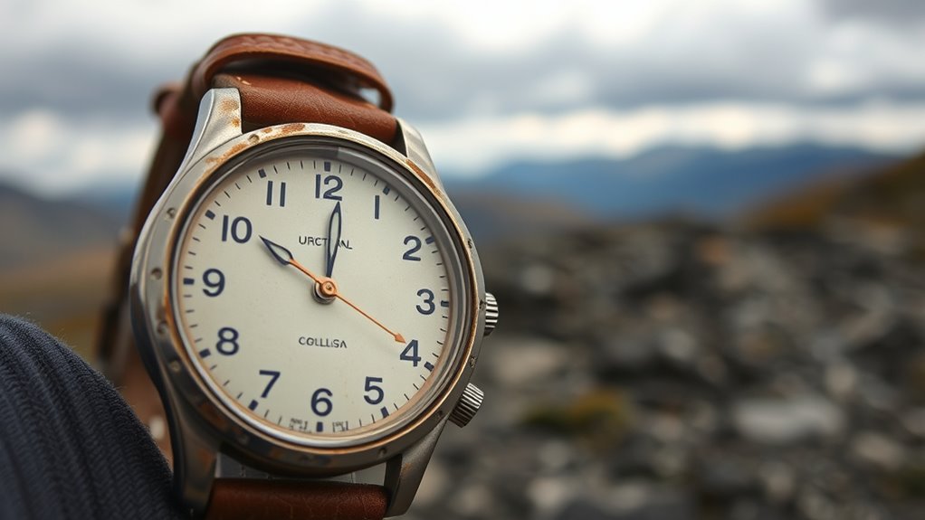
Using a wristwatch to estimate direction relies on aligning the watch with the sun’s position. In the northern hemisphere, point the hour hand at the sun, then find the midpoint between the hour hand and 12 o’clock; this line indicates south, with north directly opposite. For an analog watch, during daytime, rotate the watch until the hour hand points to the sun, then draw an imaginary line from 12 o’clock to the hour hand to find the north-south line. Shadows help confirm your estimate—at local noon, when shadows are shortest, the sun reaches its highest point, making your directional reading more accurate. Remember, this method works best when your watch is set to local time and used in clear daylight, especially around midday. Additionally, understanding the benefits of high-pressure application can improve your accuracy when estimating directions in outdoor painting scenarios. Properly accounting for visual contrast can also assist in better interpreting shadows and sun positions. Being aware of seasonal variations can further refine your estimations, as the sun’s path changes throughout the year. Recognizing the movement of the sun throughout different seasons can help fine-tune your directional estimates and avoid errors caused by seasonal shifts. Moreover, considering the angle of sunlight can boost the precision of your orientation, especially in complex outdoor environments.
Recognizing Landmarks and Environmental Cues for Orientation

Recognizing landmarks and environmental cues is essential for maintaining your orientation in unfamiliar terrain. Landmarks such as mountain peaks, rivers, lakes, and distinctive rock formations serve as critical visual references. By aligning these landmarks with your position and tracking their movement, you can confirm your course and avoid wandering in circles. Vegetation patterns, like the treeline or moss growth on trees—often more prominent on the northern side—offer subtle environmental clues. Moss growth, in particular, helps identify direction in the natural environment. Observing environmental cues such as wind direction or plant growth further enhances your natural navigation skills. Additionally, understanding the history of pinball machines can provide insight into the evolution of game design, which often influences modern pinball innovations. Consistently referencing these landmarks and environmental clues allows you to set a reliable bearing, ensuring you stay oriented even without a compass.
Combining Multiple Techniques for Reliable Navigation

Relying on a single navigation method can leave you vulnerable to errors, especially in challenging conditions. Combining celestial cues like Polaris or the Southern Cross with natural navigation techniques improves accuracy, even when one method is obscured. For example, use a shadow stick during the day to determine east-west lines, then cross-validate with environmental indicators such as moss growth or water flow. When overcast, celestial cues become harder to see, so reliance on natural cues and other natural indicators is crucial, then confirm with a compass if available. Using multiple techniques allows you to verify directions, reducing disorientation. Incorporating redundant navigation methods ensures your bearings stay accurate in any terrain or weather, even if one method fails. For instance, recognizing patterns like water flow or the growth of moss can provide critical clues for orientation in the absence of technology. Understanding local terrain features can further aid in maintaining your sense of direction and avoiding hazards. Integrating natural navigation with modern tools like maps and GPS offers backup options, ensuring your bearings stay accurate in any terrain or weather.
Frequently Asked Questions
What Can I Use if I Don’t Have a Compass?
If you don’t have a compass, you can still find your way using natural cues and simple tools. Look for Polaris, the North Star, in the night sky, or use your watch and the sun to estimate directions. During the day, create a shadow stick to find north-south, or observe environmental signs like moss on trees or the slope of cacti. These methods help you navigate effectively without a compass.
How Do People Navigate Without a Compass?
When you need to find your way without a compass, you rely on natural cues. Look for celestial markers like Polaris or the Southern Cross to identify north or south. Use the sun’s position and shadows to determine directions, and observe landmarks or landscape features to stay oriented. Skilled navigators combine these clues—stars, sun, shadows, and environment—to keep track of their route and avoid getting lost.
How to Get Directions Without a Compass?
To find directions without a compass, start by observing the Sun. It rises in the east and sets in the west, with its highest point around noon indicating south in the Northern Hemisphere. Check shadows cast by a stick—shorter ones point north in the morning and south in the afternoon. At night, find Polaris to locate true north. Use natural features like moss on trees or landscape landmarks to help orient yourself.
What to Do if You Have No Compass?
If you have no compass, don’t panic—you’re not lost yet. Use the shadow stick method: place a stick vertically in flat ground, mark the tip of its shadow in the morning and again after 15-20 minutes. Draw a line between the points to find east-west, then determine north and south. Alternatively, locate Polaris at night or observe the sun’s position during the day. Environmental clues like moss or landmarks can also help you stay on course.
Conclusion
Did you know that over 70% of outdoor navigation errors happen because people rely on a single method? By combining techniques like using the Sun, stars, landmarks, and even your watch, you considerably boost your chances of staying on track. Don’t depend on just one cue—trust multiple signals to navigate confidently. Mastering these skills not only keeps you safe but transforms any outdoor adventure into a rewarding experience.