
To learn property layouts efficiently with drone mapping, plan your flights carefully by choosing ideal paths, altitude, and overlapping images. Use flight planning tools to cover the area systematically, avoiding unnecessary wandering. Properly capturing high-resolution images from multiple angles saves time and reduces fatigue. Incorporate software to process images quickly and improve map accuracy. Keep up with the latest technology and techniques to enhance your skills and results as you explore further.
Key Takeaways
- Create a detailed flight plan with waypoints, altitude settings, and overlap to ensure complete coverage with minimal wandering.
- Use pre-programmed routes and automated flight modes to reduce manual control and fatigue during mapping.
- Break large properties into smaller sections, planning sequential flights to prevent fatigue and improve accuracy.
- Utilize mapping software for precise data processing, reducing the need for repeated flights and unnecessary wandering.
- Regularly review and adapt flight plans based on weather, obstacles, and progress to maintain efficiency and comfort.

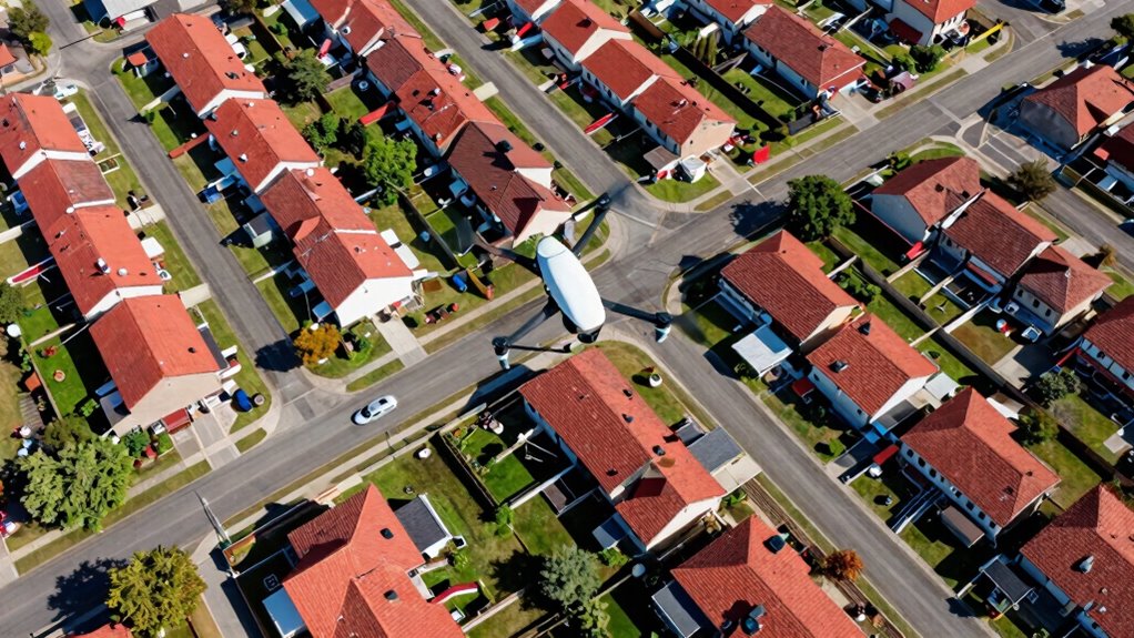
Have you ever wondered how drones can create detailed maps from the sky? It’s pretty fascinating how these flying devices can capture the layout of a property with such precision. The secret lies in their ability to perform aerial photography combined with well-executed flight planning. When you understand these core elements, you can map out property boundaries, features, and topography efficiently, without the fatigue that often comes with manual surveying.
Aerial photography is the backbone of drone mapping. By flying over a property, the drone captures high-resolution images from multiple angles. These images are stitched together using specialized software to produce thorough, detailed maps. The beauty of aerial photography with drones is that you get a bird’s-eye view, revealing aspects of the property that ground-level surveys might miss. Whether you’re determining land for development or just mapping out property boundaries, high-quality images make all the difference. They allow you to analyze terrain, identify features, and measure distances accurately. Understanding aerial photography techniques is fundamental to achieving precise and comprehensive property maps.
Aerial photography provides high-resolution, comprehensive views that ground surveys often can’t capture, ensuring precise property analysis.
However, the success of drone mapping hinges heavily on effective flight planning. Before you launch, you need to determine the best flight paths, altitude, and overlap between images. Proper flight planning guarantees that the drone covers the entire area systematically, minimizing gaps and overlaps that can compromise the map’s accuracy. Planning also involves considering weather conditions, obstacles, and no-fly zones to keep the flight safe and legal. When you set clear waypoints and altitude levels, you reduce the chances of missing essential sections of the property. Incorporating well-executed flight planning strategies can significantly improve data quality and efficiency. Additionally, understanding mapping software can help you better process and analyze the data collected during flights.
Good flight planning also helps optimize the drone’s battery life and flight time. If you’re mapping a large area, breaking it into smaller sections with planned overlaps can make the process smoother and more efficient. You’ll find that with proper planning, your drone can complete its mission faster, collect better-quality data, and reduce the need for repeated flights. Additionally, understanding flight planning techniques can help you troubleshoot and adapt to changing conditions during your flights. As you become more familiar with flight planning, you’ll develop a workflow that saves time and enhances the quality of your maps. Moreover, staying informed about latest drone technology can give you an edge in capturing even more accurate and detailed data.
In essence, mastering aerial photography techniques combined with meticulous flight planning allows you to create accurate property maps without exhausting yourself. It turns what could be a tedious task into a manageable, even enjoyable, process. With each flight, you’ll gain more confidence in your ability to map properties efficiently, making drone mapping a powerful tool in your arsenal for property assessment and management.

FAA Part 107 Drone Study Guide: a QuickStudy Laminated Reference Guide
As an affiliate, we earn on qualifying purchases.
As an affiliate, we earn on qualifying purchases.
Frequently Asked Questions
How Accurate Are Drone Maps Compared to Traditional Surveying Methods?
Drone maps are highly accurate, often comparable to traditional surveying methods, thanks to advanced sensors and GPS technology. With proper calibration, you can achieve excellent aerial accuracy and mapping precision, making drones reliable for property layout. While traditional surveys might still hold an edge for extremely detailed measurements, drone mapping offers a quick, cost-effective alternative that provides precise, detailed visuals suitable for most property planning needs.
What Types of Drones Are Best Suited for Property Mapping?
You should choose drones with high-resolution cameras, GPS stability, and obstacle avoidance features for property mapping. Look for models that support advanced mapping software, like Pix4D or DroneDeploy, which streamline data processing and improve accuracy. Multi-rotor drones are ideal for detailed, close-up surveys, while fixed-wing drones cover larger areas efficiently. Prioritize drones with reliable flight times and easy-to-use controls to make your mapping tasks smoother.
How Long Does It Take to Create a Complete Property Map?
Creating a complete property map can take anywhere from 20 minutes to several hours, depending on your drone’s mapping accuracy and calibration. If your drone is perfectly calibrated, it captures data faster and with sharper detail, reducing overall time. However, complex terrains or large properties may extend this process. Proper drone calibration guarantees precision, so invest time upfront to get a reliable map without needing repeated flights.
Are There Legal Restrictions for Drone Flying Over Private Properties?
Yes, there are legal restrictions for flying drones over private properties. You need to respect privacy concerns and follow regulations set by authorities like the FAA. Flying without permission can lead to legal issues or fines. Always check local laws and obtain necessary permissions before capturing images or videos. Staying informed about privacy restrictions guarantees you avoid legal trouble while safely using your drone for mapping or other purposes.
What Weather Conditions Are Ideal for Drone Mapping Projects?
Think of perfect weather as the steady wind beneath your drone’s wings. Ideal conditions include clear skies, low wind speeds, and stable temperatures. Weather considerations are vital, as rain, fog, or strong gusts can disrupt your flight and affect data quality. Always make sure your drone is properly calibrated before flying. Calm, sunny days provide the best environment for precise mapping, helping you capture accurate images without interruptions or hazards.

MSMV High-Resolution 4K HD Camera Drone, Wireless RC Toys for Boys Girls, One Button Return, Emergency Stop, Headless Mode, 360° Flips, 2 Batteries & Carrying Case for Kids Adults Beginners, Black
- High-Resolution Camera: 4K HD aerial video and photo recording
- Easy Flight Controls: Headless mode, one-button return, emergency stop
- Suitable for Beginners: Ideal for kids aged 8-12 and adults
As an affiliate, we earn on qualifying purchases.
As an affiliate, we earn on qualifying purchases.
Conclusion
As you master drone mapping, remember it’s more than just capturing images—it’s revealing a new perspective, like opening a window to unseen landscapes. Your drone becomes a key, turning the complex maze of property layouts into a clear, navigable map. With each flight, you carve a path through the wilderness of confusion, transforming chaos into clarity. Embrace this journey, for in each flight, you’re planting seeds of insight that will grow into understanding and mastery.

CAPART Drone Repair Tools Kit for DJI Mini 4/3 Pro Mavic 3 2 Air 2 2S Avata FPV Drone, Precision Screwdriver Set for Laptops Camera Watches Eyeglass (36 in 1)
- Compatible with DJI Drones: Suitable for DJI Mini 4/3 Pro, Mavic 3, Air 2, Avata, FPV
- Versatile Electronics Repair: Works with laptops, cameras, watches, eyeglasses
- Ergonomic Handle Design: Rotatable handle for easy, comfortable use
As an affiliate, we earn on qualifying purchases.
As an affiliate, we earn on qualifying purchases.

elecci E88 Drone with Screen Controller with SD card, Foldable Mini Drone for Beginners, 2 Batteries, 360° Flips Waypoint Fly, Active Obstacle Avoidance, One Key Take Off/Landing. (2 batteries – Black)
- Compact & Foldable Design: Easy to store and carry
- Beginner-Friendly Features: One-key start, altitude hold, 360° flips
- Extended Flight Time: Up to 24 minutes with 2 batteries
As an affiliate, we earn on qualifying purchases.
As an affiliate, we earn on qualifying purchases.